
Hill or Mountain? The Ridiculous Debate Over a Few Feet
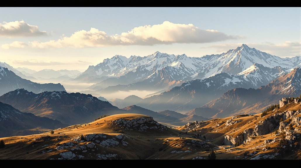
When you stand atop Scotland's Mount Keen, you're looking at a peak that barely qualifies as a mountain by UK standards, rising just above the 2,000-foot threshold. You'll notice that a mere few feet lower, and this same majestic formation would be labeled a hill, completely changing its status and significance in guidebooks and maps. It's this arbitrary line between hills and mountains that's sparked decades of debate among geographers, hikers, and local communities, revealing how our need to categorize nature often defies simple measurement.
The Fuzzy Line Between Hills and Mountains

When does a hill become a mountain? You might be surprised to learn there's no universal agreement on this distinction. While the British government informally uses 2,000 feet as a threshold, height measurement alone doesn't tell the whole story.
Different countries and organizations employ their own subjective classifications. The United Nations Environment Programme considers multiple factors, while geologists view hills simply as eroded mountains. Take Suilven in Scotland, which demonstrates how a peak can possess mountain characteristics despite being under 3,000 feet.
You'll find that steepness, terrain characteristics, and local elevation range all play important roles in determining whether a landform qualifies as a mountain. Even the U.S. Geological Survey admits the distinction is highly subjective. In fact, the U.S. Board on Geographic Names had previously established 1,000 feet of relief as the defining difference between hills and mountains before abandoning this standard.
This debate has led to various classification systems, with some enthusiasts creating their own criteria to categorize borderline cases that don't fit neatly into either category.
Cultural Perspectives on Height Classification
Cultural interpretations of what constitutes a hill versus a mountain reveal far more complexity than mere measurements.
You'll find that what counts as a mountain varies dramatically across different societies, shaped by local traditions, spiritual beliefs, and everyday experiences.

Your cultural elevation perspective might lead you to see a 1,000-foot rise as a mountain if you're from the plains, while someone from the Alps might consider it barely a hill.
These subjective perceptions aren't just personal – they're deeply rooted in language, folklore, and community identity.
The Liu Pan Shan mountains in China demonstrate how local definitions matter, as these modest elevations are culturally significant despite their relatively low height.
In the United Kingdom, elevations must reach at least 2,000 feet to earn the designation of mountain, though this standard isn't universal.
You'll notice this in how different cultures name their landscapes, from the Scottish "brae" to the French "puy," reflecting unique local understandings of terrain.
These classifications carry real-world implications, affecting everything from tourism and property values to land rights and resource management.
Why Scientific Definitions Keep Changing


Scientific definitions of hills and mountains have evolved far beyond the cultural perspectives that once dominated these classifications. This definition evolution reflects the constant advancement of our understanding, driven by improved technology and new research findings. Scientific theories evolve continuously, just as our understanding of topographical features does.
You'll find that measurement advancements have dramatically changed how we analyze topographical features. Modern tools provide unprecedented precision in measuring elevation, slope angles, and geological composition. These capabilities force scientists to regularly revisit and refine their classifications. Just as with other scientific fields, accepting new geographical definitions requires rigorous testing of proposed standards.
The process isn't simple, though. When definitions change, it affects everything from research papers to educational materials. Scientists must balance the need for accuracy with practical applications, while also considering how these changes impact different scientific disciplines.
This ongoing refinement guarantees that our understanding of geographical features remains current and scientifically sound.
Famous Cases of Height Disputes
Throughout history's most famous peaks, heated debates have erupted over their exact heights, leading to international disputes and scientific recalculations.
You'll find the most notable controversy in Everest measurements, where China and Nepal disagreed until their 2020 joint effort established the height at 8,848.86 meters.
Denali discrepancies made headlines when modern technology revealed a 10-foot difference from the 1952 survey, forcing Alaska to revise its records.
K2 uncertainty has persisted since 1856, with varying measurements including a 1987 Italian expedition claiming a different height than today's accepted 8,611 meters.
Meanwhile, Mont Blanc fluctuations continue yearly due to snow accumulation, with measurements varying by nearly a meter between 2015 and 2021.
The UIAA's prominence threshold of 600m has become a critical factor in determining whether satellite peaks can be classified as independent mountains.
These cases show how even Earth's mightiest peaks can't escape scientific scrutiny.
This modern fascination with precise measurements stands in stark contrast to the pre-18th century fear of mountains as dangerous, inhospitable places.
Modern Approaches to Elevation Categories

As mapping technology has evolved, modern approaches to categorizing elevation have become increasingly sophisticated and precise. You'll find that digital elevation models now capture surface features with remarkable accuracy, allowing for detailed classifications of landforms down to the centimeter. Triangulated Irregular Networks offer an alternative way to store and visualize elevation data with variable point locations.
Modern terrain visualization techniques have revolutionized how we perceive topographic features. Whether you're looking at a hill or mountain, you can now examine it through multiple lenses – from LiDAR-generated 3D models to photorealistic renderings that combine satellite imagery with elevation data. The latest software platforms support real-time terrain rendering that enables dynamic exploration of landscapes from any angle.
These tools don't just show you height; they reveal complex patterns of slope, aspect, and micro-topography that help define landform categories. Advanced software can automatically classify features based on multiple characteristics, moving beyond simple height measurements to evaluate the full context of the landscape.